

“Now, don’t make this any more difficult
that it is—just go thirty miles from the east to the fork in the road”
Let’s say you were having this in a live discussion as the two of you were out in the wilds of a huge wilderness of rolling hills far from any landmarks. It might go something like this:
Let’s say you were having this in a live discussion as the two of you were out in the wilds of a huge wilderness of rolling hills far from any landmarks. It might go something like this:
You: “It
is exactly thirty miles from the east to the west fork in the road.”
Person: “Where in the East?”
You: “What do you mean? You just start in the East.”
Person: “At what point in the East do I start?”
You: “That doesn’t matter.”
Person: “Of course it matters, if I am going to go thirty miles from there, I need to know exactly where to start.”
You: “Well, then, just pick a spot.”
Person: “I will never find the fork in the road doing that. I have to know where you are measuring from!”
The problem is quite evident. “In the east” is ambiguous and provides no starting point. When Mormon abridged the Large Plates of the Nephite record, he did so knowing it was for a future people to read. It seems quite strange he would have told them something and provided an ambiguous starting point as so many theorists claim.

As
Mormon stated it: “And now,
it was only the distance of a day and a half's journey for a Nephite, on the
line Bountiful and the land Desolation, from the east to the west sea” (Alma
22:32). It seems quite obvious that the purpose of this measurement is to
provide his future readers with an understanding of how wide this narrow neck
of land was. Thus he writes that it could be crossed by a Nephite in a day and
a half—from the “east to the west sea.” Can you measure in your mind how far
you could walk in a day and a half during a normal “journey”? You could come
pretty close.
The problem in understanding is that we have no starting point in the east. So, if the theorists are correct, Mormon is telling us that from some unknown point in the east, it is only a day and a half journey for a Nephite on the line or boundary of Bountiful to the West Sea.

Now, really, would Mormon pick an
unknown or unlisted place in the east from which a future reader was to
estimate the distance to the West Sea—that is, to know how wide was the narrow
neck of land?
Of this, the Mesoamericanist James L. Allen writes, in his criticism of John L. Sorenson: “Sorenson makes another error when he misreads ‘on the line Bountiful and the land Desolation, from the east to the west sea’ as ‘on the line Bountiful and the land Desolation, from the east [sea] to the west sea.’ Or, in his words, as noted previously, ‘From the east to the west sea’ seems to me probably the equivalent of ‘from the east sea to the west sea.’ The outcome of this error is that Sorenson thinks the narrow neck of land extends from the east sea to the west sea.’ That is not what Alma 22:32 says. The wording is merely “from the east to the west sea.”
So what Allen, and many other theorists try to tell us, is that while Mormon is giving us an understanding of the width of the narrow neck of land, he is not giving us a starting point by which to evaluate this measurement—thus, rendering his measurement meaningless.
Now, really, does that make sense?
Does anyone really think Mormon would have done that?
Yet, Allen goes on to insist: “The Book of Mormon does not say “from the east sea to the west sea” but merely says “on the line Bountiful and the land Desolation, from the east to the west sea.” He goes on to then say, “This aspect of Alma 22:32 deals with a defensive line “from the east to the west sea” rather than with the distance across the Isthmus of Tehuantepec from the east sea to the west sea. Again, Mormon says nothing about the distance across the narrow neck of land. Further, nowhere else in the Book of Mormon can readers find anything about the distance across the narrow neck of land. Mormon does say something about the length of the defensive lines on two different occasions—a day and a half’s journey in Alma 22:32 and a day’s journey in Helaman 4:7.”
First of all, as we have discussed on many occasions, this statement in Alma 22:32 has nothing to do with a defensive military line and is not stated in a defensive context at all, but in the sense of an overall topographical dialogue. Mormon is describing this area between the Land Northward and the Land Southward “on the line Bountiful,” that is, on the line between Bountiful and the Land Desolation, with the narrow neck all that kept the Land of Zarahemla (including the Land of Bountiful) and the Land of Nephi from being surrounded by water (Alma 22:32). Thus, this is a boundary line, and Mormon is discussing its width because it is a radically narrow area compared to the rest of the two land masses.
The defensive, or military viewpoint is stated in vs 33, in which Mormon writes in summation: “and thus the Nephites in their wisdom, with their guards and their armies, had hemmed in the Lamanites on the south, that thereby they should have no more possession on the north, that they might not overrun the land northward.” He then goes on to add, as his final remark on the topography of the two lands (Lamanite lands and Nephite lands), “Therefore the Lamanites could have no more possessions only in the land of Nephi, and the wilderness round about. Now this was wisdom in the Nephites -- as the Lamanites were an enemy to them, they would not suffer their afflictions on every hand, and also that they might have a country whither they might flee, according to their desires” (Alma 22:34).

It is interesting, as a side
note, that Mormon, who is writing 400 years later, chooses to make the point in
his insertion that preserving the Land Northward for a “country whither they
might flee” is born home when we realize that in Mormon’s time, this Land
Northward, became the Nephites last refuge, or country, to which they could
flee from the invading Lamanites. The Nephites of an earlier time were well
aware of its importance and Mormon, in his time, has come to rely on that
judgment for their homeland under the new treaty.
However, Allen is still pressing his erroneous point, as he adds, “Those defensive lines must be outside the narrow neck of land but also must be in the vicinity of the south side of the Isthmus of Tehuantepec (narrow neck of land) and must relate directly with the Pacific Ocean (west sea).” Here Allen makes four specific assumptions without any supportive rationale:
1. Defensive lines must be outside the narrow neck of land;
2. Defensive lines must be in the vicinity of the south side of the narrow neck;
3. The narrow neck is the isthmus of Tehuantepec; and
4. The Defensive lines must be directly related to the Pacific Ocean.
The problem is, as shown, when a theorist decides he knows where the Land of Promise is and it does not match the written descriptions of Mormon and others, he ends up seeing his creation or model and evaluating it instead of the scriptural references to the Land of Promise.
Allen goes on to say that he and his son, Blake, have personally explored an area near the south side of the Isthmus of Tehuantepec that may have implications for the location of the defensive lines of Alma 22:32 and Helaman 4:7. Again, the problem is, with minds made up, they combine two descriptions of lines when they refer to two different things. First, as mentioned above, the line in Alma 22:32 has to do with the division between the Land Northward and the Land South and the narrow neck of land in between, describing the configuration and giving us a rough idea of its width—that is, it is a boundary—this is somewhat comparable to the boundary between Provo and Salt Lake being the Point of the Mountain (though today that is slowly disappearing). It is not a line, but a theoretical boundary or division between two places.
In addition, the statement in Helaman 4:7 is a military line of defense, which states: “And there they did fortify against the Lamanites, from the west sea, even unto the east; it being a day's journey for a Nephite, on the line which they had fortified and stationed their armies to defend their north country” (emphasis added).

Allen goes on to emphasize an
ambiguous eastern point when he states: “Since
the initial publication of the Book of Mormon in 1830, many of its readers have
routinely wanted a Nephite to cross from ocean to ocean in a day and a half.
This verse does not say that. It does not say from the east sea to
the west sea. It says “from the east to the west sea.” It simply
states that the east orientation is the dividing line between Bountiful and
Desolation.”
So if that is true, what is the “east orientation”? Does he mean a canyon, a mountain, a river, a military post, or what? If he is not going to tell us what that eastern point is, then why bring it up, since it is not helpful or even of any value to know it is in the east.
In addition, the verse in Helaman does not say anything about an eastern point at all. It gives no indication of the east in anyway, though it is describing the narrow neck of land which is mentioned earlier in Mormon’s insertion.
Lastly, on this, Allen states: “The west orientation is the west sea, which we believe is the Pacific Ocean by the Gulf of Tehuantepec. According to our model, the day-and-a-half marker begins near the archaeological site of Tonala (candidate for the city of Melek) on the east and ends at the ocean fishing village of Paredon on the west.
Once again, having his own model in mind, he then goes on to tell us what the scriptural record states and means, adding, “The distance is twelve miles, which is consistent with Maya travel distance of eight miles a day—or twelve miles in a day and a half.”
If travel of a Nephi was only 8 miles in a day, that indeed would be something of interest for by all other accounts, such a low distance is never stated elsewhere except in Allen’s mind, unless the topography is very difficult. It took Balboa three weeks to cross the Isthmus of Panama—a distance of about 30 miles. But it took Alma 21 days to get from the Waters of Mormon to Zarahemla—at eight miles a day making that distance only 168 miles apart, which is a considerably short distance to separate these two warring societies.
(See the next post, “Is Mormon Playing Games With Us? – Part II, for more information on James L. Allen’s critique of John L. Sorenson, both Mesoamericanists, of the latter’s claims about his location for the Land of Promise in Mesoamerica)
Person: “Where in the East?”
You: “What do you mean? You just start in the East.”
Person: “At what point in the East do I start?”
You: “That doesn’t matter.”
Person: “Of course it matters, if I am going to go thirty miles from there, I need to know exactly where to start.”
You: “Well, then, just pick a spot.”
Person: “I will never find the fork in the road doing that. I have to know where you are measuring from!”
The problem is quite evident. “In the east” is ambiguous and provides no starting point. When Mormon abridged the Large Plates of the Nephite record, he did so knowing it was for a future people to read. It seems quite strange he would have told them something and provided an ambiguous starting point as so many theorists claim.

Using the descriptions found in the
scriptural record, the above image represents the area between the Land of
Desolation (Land Northward) and the Land of Bountiful (Land Southward), with a
boundary line between them across the “small neck of land.” Now we do not know
if that (red-dotted) line was in the center of this stretch of land (as shown)
or toward the north or south within that stretch of land, however, it was a
dividing line or boundary between these two lands
The problem in understanding is that we have no starting point in the east. So, if the theorists are correct, Mormon is telling us that from some unknown point in the east, it is only a day and a half journey for a Nephite on the line or boundary of Bountiful to the West Sea.
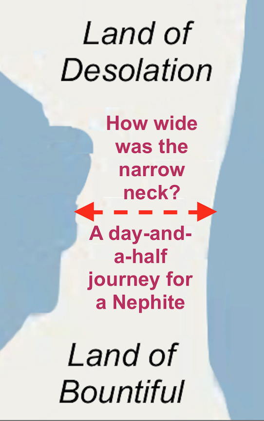
Mormon is answering his own question about the width of the narrow neck
of land, but telling us that a Nephite could cross the small neck in
a-day-and-a-half
Of this, the Mesoamericanist James L. Allen writes, in his criticism of John L. Sorenson: “Sorenson makes another error when he misreads ‘on the line Bountiful and the land Desolation, from the east to the west sea’ as ‘on the line Bountiful and the land Desolation, from the east [sea] to the west sea.’ Or, in his words, as noted previously, ‘From the east to the west sea’ seems to me probably the equivalent of ‘from the east sea to the west sea.’ The outcome of this error is that Sorenson thinks the narrow neck of land extends from the east sea to the west sea.’ That is not what Alma 22:32 says. The wording is merely “from the east to the west sea.”
So what Allen, and many other theorists try to tell us, is that while Mormon is giving us an understanding of the width of the narrow neck of land, he is not giving us a starting point by which to evaluate this measurement—thus, rendering his measurement meaningless.
Now, really, does that make sense?
Does anyone really think Mormon would have done that?
Yet, Allen goes on to insist: “The Book of Mormon does not say “from the east sea to the west sea” but merely says “on the line Bountiful and the land Desolation, from the east to the west sea.” He goes on to then say, “This aspect of Alma 22:32 deals with a defensive line “from the east to the west sea” rather than with the distance across the Isthmus of Tehuantepec from the east sea to the west sea. Again, Mormon says nothing about the distance across the narrow neck of land. Further, nowhere else in the Book of Mormon can readers find anything about the distance across the narrow neck of land. Mormon does say something about the length of the defensive lines on two different occasions—a day and a half’s journey in Alma 22:32 and a day’s journey in Helaman 4:7.”
First of all, as we have discussed on many occasions, this statement in Alma 22:32 has nothing to do with a defensive military line and is not stated in a defensive context at all, but in the sense of an overall topographical dialogue. Mormon is describing this area between the Land Northward and the Land Southward “on the line Bountiful,” that is, on the line between Bountiful and the Land Desolation, with the narrow neck all that kept the Land of Zarahemla (including the Land of Bountiful) and the Land of Nephi from being surrounded by water (Alma 22:32). Thus, this is a boundary line, and Mormon is discussing its width because it is a radically narrow area compared to the rest of the two land masses.
The defensive, or military viewpoint is stated in vs 33, in which Mormon writes in summation: “and thus the Nephites in their wisdom, with their guards and their armies, had hemmed in the Lamanites on the south, that thereby they should have no more possession on the north, that they might not overrun the land northward.” He then goes on to add, as his final remark on the topography of the two lands (Lamanite lands and Nephite lands), “Therefore the Lamanites could have no more possessions only in the land of Nephi, and the wilderness round about. Now this was wisdom in the Nephites -- as the Lamanites were an enemy to them, they would not suffer their afflictions on every hand, and also that they might have a country whither they might flee, according to their desires” (Alma 22:34).

Before and After: Left: Before the
geographical changes due to the Crucifixion, with two seas shown; Right: After
the Crucifixion when the “there was a great and terrible destruction in the
land” and one sea shown after the Andes Mountains rose in the three hours as
“there shall be many places which
are now called valleys which shall become mountains, whose height is great”
However, Allen is still pressing his erroneous point, as he adds, “Those defensive lines must be outside the narrow neck of land but also must be in the vicinity of the south side of the Isthmus of Tehuantepec (narrow neck of land) and must relate directly with the Pacific Ocean (west sea).” Here Allen makes four specific assumptions without any supportive rationale:
1. Defensive lines must be outside the narrow neck of land;
2. Defensive lines must be in the vicinity of the south side of the narrow neck;
3. The narrow neck is the isthmus of Tehuantepec; and
4. The Defensive lines must be directly related to the Pacific Ocean.
The problem is, as shown, when a theorist decides he knows where the Land of Promise is and it does not match the written descriptions of Mormon and others, he ends up seeing his creation or model and evaluating it instead of the scriptural references to the Land of Promise.
Allen goes on to say that he and his son, Blake, have personally explored an area near the south side of the Isthmus of Tehuantepec that may have implications for the location of the defensive lines of Alma 22:32 and Helaman 4:7. Again, the problem is, with minds made up, they combine two descriptions of lines when they refer to two different things. First, as mentioned above, the line in Alma 22:32 has to do with the division between the Land Northward and the Land South and the narrow neck of land in between, describing the configuration and giving us a rough idea of its width—that is, it is a boundary—this is somewhat comparable to the boundary between Provo and Salt Lake being the Point of the Mountain (though today that is slowly disappearing). It is not a line, but a theoretical boundary or division between two places.
In addition, the statement in Helaman 4:7 is a military line of defense, which states: “And there they did fortify against the Lamanites, from the west sea, even unto the east; it being a day's journey for a Nephite, on the line which they had fortified and stationed their armies to defend their north country” (emphasis added).

This military line, or stone wall, is located in the northern part of
Peru, following the River Santa from the coast to the mountains—the region is
very mountainous and the wall is located on the hillsides of the valley, with
the Santa River marking the end of the Santa Valley. The Shippee-Johnson
expedition that originally photographed the wall from both the air and ground,
estimated that the wall in its original form had been 12-15 feet thick and
12-15 feet high, but in some places as high as 20 feet which still stands
today. The wall was described as made out of broken rocks and adobe cement and
writes that is was very smooth in the places where the surface was still intact.
They also stated that “Clearly the wall with its double line of forts was
erected as a defensive barrier” and later analysis places the construction
between 900 and 200 B.C.
So if that is true, what is the “east orientation”? Does he mean a canyon, a mountain, a river, a military post, or what? If he is not going to tell us what that eastern point is, then why bring it up, since it is not helpful or even of any value to know it is in the east.
In addition, the verse in Helaman does not say anything about an eastern point at all. It gives no indication of the east in anyway, though it is describing the narrow neck of land which is mentioned earlier in Mormon’s insertion.
Lastly, on this, Allen states: “The west orientation is the west sea, which we believe is the Pacific Ocean by the Gulf of Tehuantepec. According to our model, the day-and-a-half marker begins near the archaeological site of Tonala (candidate for the city of Melek) on the east and ends at the ocean fishing village of Paredon on the west.
Once again, having his own model in mind, he then goes on to tell us what the scriptural record states and means, adding, “The distance is twelve miles, which is consistent with Maya travel distance of eight miles a day—or twelve miles in a day and a half.”
If travel of a Nephi was only 8 miles in a day, that indeed would be something of interest for by all other accounts, such a low distance is never stated elsewhere except in Allen’s mind, unless the topography is very difficult. It took Balboa three weeks to cross the Isthmus of Panama—a distance of about 30 miles. But it took Alma 21 days to get from the Waters of Mormon to Zarahemla—at eight miles a day making that distance only 168 miles apart, which is a considerably short distance to separate these two warring societies.
(See the next post, “Is Mormon Playing Games With Us? – Part II, for more information on James L. Allen’s critique of John L. Sorenson, both Mesoamericanists, of the latter’s claims about his location for the Land of Promise in Mesoamerica)


No comments:
Post a Comment