
2. Where he settled and what he did there.
To the north of the Atacama Desert is an area of extremely old and extremely impressive ruins, beginning with an area called Tiahuanaco, which is just east of the southern shore of Lake Titicaca, and an area adjacent to the south called Puma Punku

Tiahuanaco and Puma Punku to the south and east of Lake Titicaca. Their
magnificent ruins date well into B.C. times
Tiahuanuco lies almost in the very center of the great terrestrial basin of lakes Titicaca and Aullagas, and in the heart of a region, which may be properly characterized as the Tibet of the New World. Here, at an elevation of twelve thousand nine hundred feet above the sea, in a broad, open, unprotected, arid plain, cold in the wet and frigid in the dry season, we find the evidences of an ancient civilization, regarded by many as the oldest and the most advanced of both American continents. Known variously as Tiwanaku (Spanish: Tiahuanaco and Tiahuanacu) it is an important Pre-Columbian archaeological site in western Bolivia along the border with Peru.
Even in ruins, it is an impressive site. Arthur Posnansky claims it is one of the oldest man-made monuments in the world, and refers to it as “the cradle of American Man.” Many archaeologists claim Tiahuanaco is the solitary remains of a civilization that disappeared long before the Inca began, and contemporaneous with that of Egypt and the East.

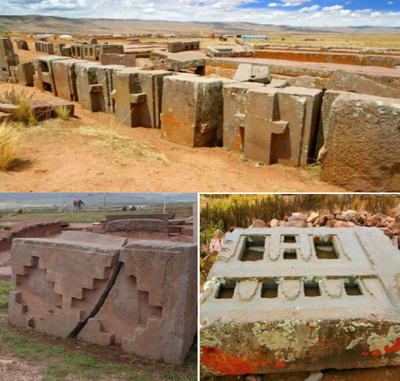
Elaborate designs are carved into numerous stones, now tumbled in ruin,
but once comprising a huge wall, in which the designs would only appear when
connected
Tiahuanaco is an example of engineering so monumental that it dwarfs even the work of the Aztecs. Stone blocks on the site weigh up to 65 tons. They bear no chisel marks, so the means by which they were shaped remains a mystery. The stone itself came from two different quarries. One supplied sandstone and was situated 10 miles away. It shows signs of having produced blocks weighing up to 400 tons. The other supplied andesite and was located 50 miles away, raising the question of how the enormous blocks were transported.
Close examination of the structures shows an unusual technique behind their building. The stone blocks were notched, then fitted together so that they interlocked in three dimensions.
The result was buildings strong enough to withstand earthquakes.
Until very recently, orthodox archaeologists labeled Tiahuanaco a ritual site. The reason was that it was built as a port. It has docks, it has quays, it has harbors. But they are docks, quays and harbors that can’t be used by any ship. Tiahuanaco is situated nearly 13,000 feet above sea level and is miles from the nearest water. However, there is evidence that at one time Tihuanaco and Puma Punku were at sea level and the Andes rose and trapped Lake Titicaca within its deep canyons, with mountain cliffs showing signs of sea water levels and ruins showing signs of once have been covered with water.
Recently, new archaeological discoveries clearly showed it was once not only a bustling metropolis, but also the capital of an ancient empire extending across large portions of eastern and southern Bolivia, north-western Argentina, northern Chile and southern Peru.
One of its most extraordinary accomplishments was a unique system of agriculture that involved the creation of raised planting surfaces separated by small irrigation ditches. These ditches absorbed sunlight and prevented crops from freezing, even on the high Altiplano.
To
the north of Lake Titicaca, along a Valley the Inca called Sacred, lies several ancient sites dating long before the
Inca came to power. The major ancient city is now called Sacsayhuaman, though
no one knows what it was called by its builders and occupants. The fortress,
temple, and towering complex once dominated a hillside that overlooks Cuzco,
the city the Inca called their capital. The ancient construction, with its
miraculous fitting of dressed and cut stones of odd angles, today understood as
to withstand earthquakes, for which the area is well known.

There is an interesting part of
the City of Nephi that included a tower several stories tall on which a Nephite
could stand upon and see into the adjoining valleys of Shilom and Shemlon
(Mosiah 11:12) and from there see approaching Lamanite armies (Mosiah 19:6-7).

Top: One of the three tiered defensive walls of
the fortress surrounding Sacsayhuaman above Cuzco. The zig-zag design with
doorways through the tiers staggered at distant intervals made this fortress
almost impregnable; Bottom: The size of these stones were “humungus” and
weighted hundreds of tons, baffling modern engineers as to how they got the
stones to this location and hoisted them into place

Top: The Tower base that held the seven story round tower with a observation level of the top positioned near the cliff where
one could look out over the entire valley and into the two valleys to either
side and all entrances from there into the valley. Note: the size of a person
(yellow arrow); Bottom: Aerial view of the cliff top, showing the three tiered
zig-zag wall at the top and the (white arrow) tower based in the middle. It is
next to the Temple (right) and the complex monumental structures of the ancient
city
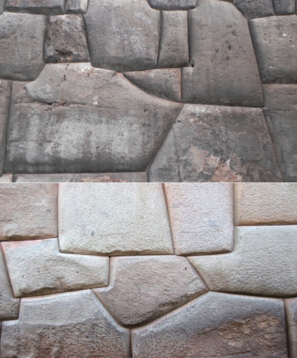
The unusually cut stones that are perfectly
fitted that not even a razor blade could fit between the seams. Only an
advanced understanding, such as God’s as he told Nephi how to build a ship,
could have produced such knowledge for man and, no doubt, the many things the
lord showed Nephi probably included how to build since Nephi taught his people
how to do so

So sturdy and solidly well built, the
ancient Peruvian stonework was left intact and used as the foundation for much
of the Spanish building a thousand years after the Nephites built their
stonework. The (yellow arrows) major Spanish cathedrals were build on these
ancient foundations, as well as the city buildings

Much of the old city of Cuzco, built by the
Spanish, was built on the magnificent stonework walls the ancient Peruvians
built a thousand years earlier

(See the next post, “Finding Lehi’s Isle of Promise – Part VIII,” for an explanation of Jacob’s view of the Land of Promise, and Amaleki’s coverage of Mosiah’s move further northward)


No comments:
Post a Comment